Hiking Mount Apo, Philippines
The highest mountain of the Philippines
📌 By Jakub Mikula | August 22, 2019
In August 2018, my friend and I set out to hike Mount Apo (2954m) - the highest mountain in the Philippines. It usually takes two to three days to hike - we managed to do it in two days (one night).
At the start, I found the hike relatively easy; however, once we climbed above the tree line, the conditions became surprisingly harsh, with cold, windy air forcing us to take shelter behind big rocks.
On this hike, my friend and I were accompanied by two mountain guides, who carried most of the luggage, a tent, and food for cooking.
We first landed in Davao, where we met our guide and took a bus to Digos City. From there, we were taken to the first camp in Kapatagan. We were picked up by guys from Kapatagan on huge motorcycles, giving us a ride from the Digos bus terminal to the Kapatagan camp. We started the ride after dark and rode through a pitch-dark forest. At high speed, with heavy luggage loaded, and seeing only a sharp cone of light reflecting off the trees around us, it was exhilarating and packed with adrenaline. Soon we reached the camp, where we had dinner and spent the night in a tent.

We were woken up shortly after 5am to a beautiful morning. I stepped out of the tent, navigated through little cute chicks following their mum around, and made my way to the breakfast table, where the guides were already packing the luggage and making preparations for the hike.
We started our hike at 7am, following a green trail from the village and soon plunging into the lush forest.

At first, the trail was relatively easy, and we made good time until we reached the first camp (11am) near a small water source. We cooked lunch and continued. Many hikers stay here overnight and wake up early in the morning to hike to the summit. Since we were a small group, we were allowed to continue and spend the night much closer to the summit.

As we climbed higher, the terrain grew more demanding.
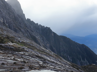
Above the tree line, we scrambled over large boulders, some stained greenish by sulfur, with its sharp scent lingering in the air.
With the shelter of the forest gone, the wind hit hard, often forcing us to take shelter behind some of the big rocks.

When we emerged near the summit, it was 4pm.
We pitched a tent, cooked dinner, wandered around admiring the rock formations, and soon went to sleep, ready to wake up early the next morning.
As I drifted off, I could hear the wind swishing across the mountain and rattling the tent so fiercely that I was afraid it might lift us up and carry us away.

We woke up early in the morning at 5am, had a quick breakfast, and continued to the summit.
The summit was only one hour away.
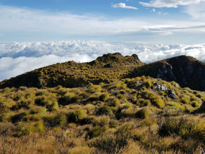
When we arrived, the early-morning clouds blocked most of the views, but later, as the strong wind tore them apart, the scene that opened up left me speechless, revealing the mountain as if it were floating above a sea of clouds.


Many craters were also filled with water.

We started our descent at around 7am, navigating the slippery slopes of the wet morning trails.

We got back at around 11am, satisfied with our hike and the beautiful experience of adding the highest mountain in the Philippines to our list of achievements.